A Windmill Site in Harberton?
This article is included by kind permission of the author, Stanley Oldfield.
A Windmill Site in Harberton?
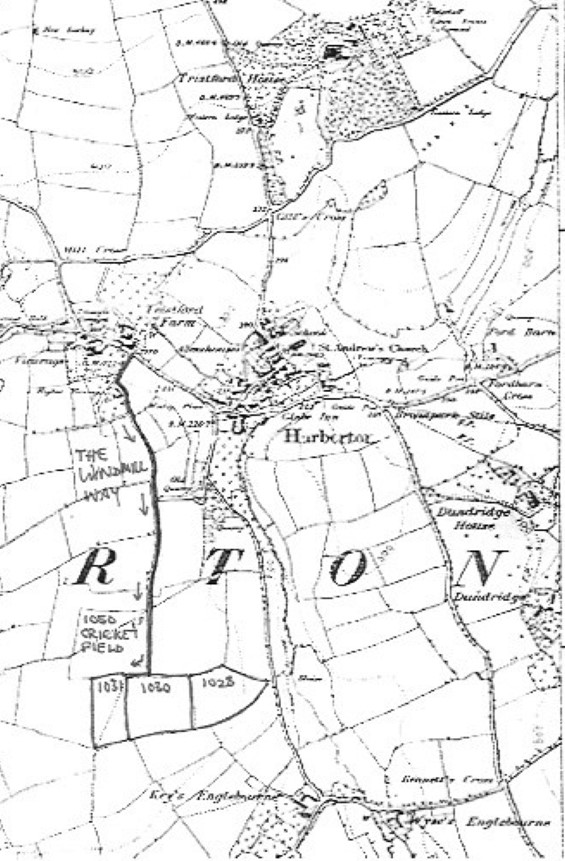
When you come to play cricket in Harberton you follow the road through the bottom of the village heading for Leigh Bridge and Diptford, and take a left turn up a lane opposite Tristford Farm signposted to Harberton Cricket Club. After about half a mile, when you get almost to the end of the lane, the cricket pitch is on your right.
If, instead of going onto the cricket pitch, you carry on up the lane past the entrance to the cricket field and take the sharp right hand bend the lane comes to an abrupt end with gates into two fields. In the 1842 Tithe Apportionment for Harberton the field right ahead of you was called Windmill (1031), the field on your left was called Higher Windmill (1030) and the field to the left of that was called Lower Windmill (1028). The cricket field itself was called Stonehills (1050). Interestingly the Windmill was part of the Glebe lands owned by the Rev George Martin, as the vicar of Harberton at the date of the Tithe Apportionment, whereas the other adjacent fields were in the ownership of Preston Farm.
A further clue suggesting that there was once a windmill at this site is the fact that the lane up which you came to reach the cricket field is referred to as The Windmill Way in a Harberton Glebe Terrier from about 1680.
There is nothing presently visible from the air (I was fortunate enough to be able to view the site from a helicopter in 1979 while I was working at the Britannia Royal Naval College) nor is there any noticeable surface distribution of pottery or other material in these fields that might identify the site. I have not yet come across any documentary references to a windmill in Harberton other than the evidence from the 1842 tithe map and the 1680 Glebe Terrier. The position is a good one on the top of a hill and about equidistant from the village of Harberton and from the 2 hamlets of Englebourne and East Leigh. The availability of water power as the alternative energy source from the nearby Harbourne river possibly led to a fairly early end to the mills operation.
Professor Walter Minchinton from Exeter University had published his book Windmills of Devon in 1977. I corresponded with him in 1979 about my uncovering of the above facts and in 1980 when he published a paper in Devon and Cornwall Notes and Queries entitled Yet Further Devon Windmills he was kind enough to include our windmill site in Harberton along with several others that had also come to light following the publishing of his book.
References:
1. Minchinton Walter (1977) Windmills of Devon, Exeter Industrial Archaeology Papers
2. Minchinton Walter (1980) Yet Further Devon Windmills, Devon and Cornwall Notes and Queries Vol XXXIV Part IV pp. 238-240
3. Harberton GlebeTerrier c 1680 signed by Charles Evelegh who was vicar of Harberton 1678 to 1691 (an 1821 transcription of this is held by Devon Heritage Centre DEX/8/a/171)
4. The 1842 Harberton Tithe Map and Tithe Apportionment are available online at https://www.devon.gov.uk/historicenvironment/tithe-map/harberton/.
The map below, showing the location of the Windmill Lane
and the three fields with names relating to the windmill is my annotated version
of the relevant section of the 1:10,560 scale
Ordnance Survey Map sheet 120/SE, which can be found at
http://www.british-history.ac.uk/os-1-to-10560/devon/120/se
[Note that the map also shows the old Harberton Vicarage, nowadays known as the Manor]